Barge
Workshop Re-Opening
With completion of the restoration work on the basin at Helebridge, the
Barge Workshop will now be open and manned by Trustees and friends from
2 - 5pm each Sunday until the end of September. A further opportunity
to view the tub boat and other exhibits.
Bude
Canal Regeneration Project
NCDC have been given approval for the stage 1 bid of a
2-stage application to H.L.F. for the canal project.
Stage 1 is the development stage and funds have been released by H.L.F.
and the other funders to develop the project so that it will qualify for
the Stage 2 grant. Part of Stage 1 is the employment of a Project Manager
and a Project Technician to ensure that the Stage 2 bid will be successful.
The Development Phase will last for 6 months.
Whilst a successful Stage 1 does not guarantee success with the Stage
2 bid it is a very positive sign from H.L.F. and means that the total
amount agreed for the project from H.L.F. has been set aside.
A successful Stage 2 bid would unlock the door to the other funds pledged
for this £4.6 million project which will revitalise the watered
section between Bude and Helebridge and bring opportunity to the canal
corridor as better access, interpretation and walking routes come on line.
Chris Jewell
back
to contents
Rolle
Canal Society Visit Bude Canal
With some common roots and features, not to mention their relatively close
proximity, it is, perhaps, not surprising that the two canal societies
are on more than just nodding terms. It was, therefore, a pleasure to
be able to show the more recently formed Rolle Canal Society some of James
Green's great engineering achievements, still preserved along the lengths
of the Bude Canal.
The weather was kind, i.e. DRY, on the day and members of your Committee
welcomed the group from the Rolle Canal Society at 10 a.m. on the Lower
Wharf area where Mr. Chris Jewell gave a brief outline of the day's schedule
and issued the visitors with individual information packs, so that they
would have a better idea of the geography of the trip.
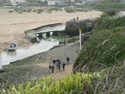
The journey through time started at the breakwater and it was explained
how this had achieved sheltered waters for the harbour and enabled the
canal to lock directly into the Atlantic Ocean.
The tide being out, we were then able to walk along the beach back towards
the sea lock of the canal along the bank of the River Strat, which had
been diverted to provide a deep water channel to the sea lock. Viewed
from this level, the sea lock and its gates are quite dwarfing to us mere
humans.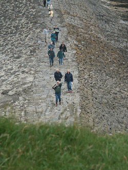
On climbing up to the lockside, we were able to look down into the lock
and appreciate its depth, width and length and imagine the size of the
ships that plied their trade during the canal's heyday: the Elizabeth,
the Agnes, Wildpigeon, Ceres and many more; bringing in their cargoes
of coal and timber etc. and exporting oak bark and scrap metal etc. It
was then explained how the canal was originally conceived: to transport
sand from Summerleaze Beach by barge and tub boat to farms inland, to
enable the farmers to treat their poor, heavy soils with mineral rich
sand, which improved the condition and the drainage of the farmland when
once they had had to collect the sand themselves on packhorses. This is
one of the reasons why the Bude Canal is historically so important, being
founded for agricultural purposes and not heavy industry.
Initially it had been intended to sail the empty barges out through the
sea lock, beach them and load them with sand and then sail them back into
the canal. This method was superseded by sand wagons that ran on a network
of rails across the beach, crossed the river on the iron bridge and then
along an embankment, between the river and the canal, on rails along to
the wharf, where they were emptied into waiting barges or, later, tub
boats. The remains of the sand rails and the turntable are still visible
to this day.
Once the tub boats / barges were loaded, they were towed up the Canal
by horse and this was the route which we now followed, stopping at points
of interest along the way, such as: the Blacksmith's shop (now the Museum);
The Bark House, where oak bark was stored awaiting shipment out; wharf
warehouse, now The Brasserie Restaurant; the old Lifeboat House, now holiday
flats; the Granary warehouse, now private apartments; Stapleton's shipyard,
where many of the Bude sailing ketches were built and launched directly
into the Canal, now home to the Bude Band and the Scouts; the Castinghouse
works, where chains and other iron foundry work was carried out.
We continued, past one of the Castinghouse products, the 1 mile marker.
This is one of the few remaining markers which used to stretch along the
whole of the 36 miles of the canal to enable the boat owners to charge
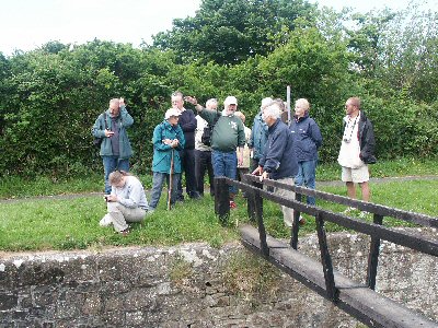
their customers carriage by the mile. Eventually we reached the first
disused inland lock at Rodd's Bridge Farm. This, at present, has no gates,
the inner ones being replaced by a brick overspill wall. It was explained
that the intention is to restore this lock and the one further on at Whalesborough
and thus have the whole 2 miles of canal currently in water, open to boat
traffic again, once the Canal Project obtains its funding and gets the
go ahead. Something to relish for the future.
Pangs of hunger were now evident, so we retraced our steps to the Falcon
Hotel for some needy refreshment and to digest the morning's facts and
figures.
Suitably refreshed we eagerly made ourselves ready for the afternoon excursions.
In an effort not to congest the Cornish lanes too much, we "sardined"
ourselves into as few vehicles as was safely possible and set out for
the Barge Workshop at Hele Bridge. This is beside the pound situated at
the end of the water section approx. 2 miles from the sea lock. It is
at the foot of the first inclined plane, Marhamchurch. Inside the workshop
is an original tub boat, which had been rescued from the depths of the
canal some years previously. The tub boat is in remarkably good condition
and allows one to imagine better, how they would have operated and traversed
the incline planes.
After the Barge Workshop and tub boat, it was back into the cars and off
to view Hobbacott Inclined Plane.
 This
is the largest of the inclined planes. It raised the tub boats a height
of 225 feet from one level of watered canal up to the next level of watered
canal. This was achieved over a distance of 935 feet. The means of propulsion
was by two large iron buckets, each holding approx. 15 tons of water.
There were two vertical shafts 225 feet in depth. Each shaft housed one
of the buckets. Whilst one bucket would fill with water at the top of
one shaft, the other bucket would be automatically emptying at the bottom
of the other shaft. When the bucket was full, it would descend to the
bottom of the shaft whilst, simultaneously, the empty bucket would be
rising in the other shaft. When the full bucket reached the bottom of
the shaft, a valve in the bottom of the bucket was activated and the bucket
would empty. Meanwhile, the other bucket, now at the top of the other
shaft, would be filling with water, thus allowing the whole cycle to repeat
itself. It is said that the loaded tub boats ascended the inclined plane
in approx. 4 minutes. This
is the largest of the inclined planes. It raised the tub boats a height
of 225 feet from one level of watered canal up to the next level of watered
canal. This was achieved over a distance of 935 feet. The means of propulsion
was by two large iron buckets, each holding approx. 15 tons of water.
There were two vertical shafts 225 feet in depth. Each shaft housed one
of the buckets. Whilst one bucket would fill with water at the top of
one shaft, the other bucket would be automatically emptying at the bottom
of the other shaft. When the bucket was full, it would descend to the
bottom of the shaft whilst, simultaneously, the empty bucket would be
rising in the other shaft. When the full bucket reached the bottom of
the shaft, a valve in the bottom of the bucket was activated and the bucket
would empty. Meanwhile, the other bucket, now at the top of the other
shaft, would be filling with water, thus allowing the whole cycle to repeat
itself. It is said that the loaded tub boats ascended the inclined plane
in approx. 4 minutes.
With the consent of the present landowner, we were able to view the whole
length of the inclined plane, which is in a very good, intact condition.
The views obtained allowed one to appreciate more fully the scale of the
operations that would have taken place there.
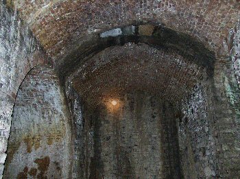
The next stop was the wheelpit at the top of the Merrifield inclined plane,
where we were met by the present landowner, who welcomed us and, as with
the Hobbacott landowner, very kindly allowed us access over his land.
The Merrifield inclined plane allowed the tub boats to descend to the
next level of water. In total the drop was 60 feet over a distance of
360 feet. Unlike Hobbacott, the method of propulsion here was by means
of a 30 feet diameter water wheel. The wheel was housed in a wheel pit
approx. 30 feet deep and 30 feet across and 10 feet wide. To either side
of the wheel pit, were areas for access and for the machinery gears to
be housed. The whole structure is in such remarkably good condition, apart
from the absence of the wheel and its associated machinery, that we were
able to gain access and see quite clearly the structure and how it would
have operated. It is a tribute to the engineers and builders of the time,
that this brick built structure still remains almost intact, after all
these years. From the vantage point of what would have been about axle
level of the wheel, the sheer scale of the structure is overwhelming.
Looking up at the brick built, domed roof felt akin to being in a cathedral.
A truly, wonderful experience.
 The
next port of call was to be the Lower Tamar Lake. This lake was the water
supply for the canal system. We then walked along the Bude Aqueduct feeder
channel to Virworthy Wharf, where this section of the canal starts/terminates. The
next port of call was to be the Lower Tamar Lake. This lake was the water
supply for the canal system. We then walked along the Bude Aqueduct feeder
channel to Virworthy Wharf, where this section of the canal starts/terminates.
The feeder aqueduct is, by and large, in good condition but very overgrown
with weed. The embankment, by its side, is kept open to walkers by the
owners, Bude Canal Trust (no connection with The Bude Canal and Harbour
Society) and is generally well mown and passable.
At Virworthy Wharf we were met by another of our members, who lives nearby,
Mr. Geoff Lowe. The Wharf building is in a good state of repair and houses
a display of the canal and its workings. In the past, the building would
have stored coal and sand etc., which had been off-loaded from the tub
boats.
This, then, was the end of our day of exploration, a very successful occasion
indeed and a privilege to have been able to view some of the lesser accessible
features of the canal. A warm and very well deserved, round of applause
was given to our guide of the day for organising and arranging the visits.
We all then departed, contentedly tired, back to Bude for some refreshment.
All in all, a very successful day, which demonstrated clearly how much
of interest there still is on the ground, along the whole route of the
Bude Canal system. It surely deserves to be restored and preserved for
all to enjoy, both now and in the future. Let's hope that the, long awaited,
Canal Regeneration Project soon achieves some of the lesser accessible
features of the canal.
David Phillips
back
to contents
World Pilot Gig Championships
Having seen Bude Gig society's first gig, "Bedehaven",
launched on to the canal last summer, I was pleased to see the Ladies
section rowing her in the annual World Pilot Gig Championships at St Mary's
Isles of Scilly on Sunday May 1st to as creditable 68th place out of 81.
We should have flown from Newquay airport (St Mawgan) on the Saturday
but thick fog blanketed the islands from about 11 am and so we were sent
home. We rose at 5.30am next day to drive back to St Mawgan where we boarded
a coach to Penzance for a special sailing of Scillonian III to St Mary's.
Sad to say I was seasick for the last half-hour of the two and a half
hour journey.
We did not see the men's race in which Bedehaven came 65th out of 92.
I am happy to say we were able to return in a Twin Otter to Newquay on
Saturday 7th May after a most enjoyable week spent exploring the islands
PS: My daughter-in-law rowed in Lyonesse to 45th place.
back
to contents
In
answer to Geoff Lowe's question in "Virworthy View" in the Spring
edition of The Tub Boat about the mill on the Lower Tamar lake Bill Young
has sent a copy of the OS map of 1891 (surveyed in 1881-84) used by Monica
Ellis (and himself later) in writing her book "The Bude Canal",
and the notes on numbered places in the map written by her in 1969.
Geoff's query referred to a mill on the edge of Lower Tamar Lake. This
is shown as "New Mill" on the map and numbered 8 by Monica Ellis.
She says it was a corn mill and was last worked in 1929 by Sid Bond. It
was taken down in 1949.
Ed
back
to contents
Visit
to Blagdon Water & Blagdonmoor Wharf
On the 28th May an invited group of Trustees visited Blagdon Water courtesy
of Dermot O'Neill who is a member of the Bude Canal and Harbour Society.
Blagdon Water is a man made lake created to provide a location for a static
replica barge as a holiday facility available for hire. The whole site
covers an area of 35 acres which includes 3 acres of lake. The boat, the
Painted Lady, is being fitted out to accommodate four persons in two cabins.
The creation of the lake has increased the biodiversity in that area.
Adjacent to BlagdonWater is a "Sand Trail" which was one of
the tracks from Blagdonmoor Wharf used by farmers to carry sand brought
by canal from Bude to use on the land as a fertiliser.
The group walked along the Sand Trail to Blagdonmoor Wharf where we were
met by Robert Montague, a resident and chairman of the local history society.
Blagdonmoor Wharf was the terminus of the Holsworthy arm of the canal.
Whilst most of the wharf area is now built on, the original wharf building
remains and some of the canal channel, which is overgrown, can still be
seen. However, there are remains of the initial workings in a deep channel
beyond the wharf where it was intended to build a tunnel to extend the
canal further into Devon. This was never achieved because of lack of finance.
After the guided visit, the group had an interesting discussion about
the Bude Canal and its future.
Our thanks to Dermot O'Neill, Robert & Rosa Montague and to Nick Shadrick
for permission to use the Sand Trail which is on private land.
Betty Moore
back
to contents
Virworthy
View
Halfway through the year and summer has come in odd days, some hot, some
cold, some wet! I swear that the flora is bigger and better this year
as a result of the very wet spring. Cow parsley is now reaching over six
feet in height. The canal basin is too overgrown to see the water now,
to the consternation of the dogs that try to walk on the top grass. Our
new dog is slow to learn this and consequently spends much time under
the tap.
I do believe there are fewer birds about this year, judging by the lack
of bird songs in the mornings. There is also a scarcity of honey bees,
probably due to the bee mite 'aerroa destructor'. The swallows are few
and far between too, although we do have one pair nesting in the garage.
Usually there are at least two pairs and sometimes three. The first brood
of five have flown and I am sure they are sitting again. We have now been
blessed with a pair of squirrels. There is often one hanging upside down
eating the peanuts on the bird feeder together with a greater spotted
woodpecker - our peanut bill is rising rapidly - perhaps the squirrels
will stock up with the usual abundant crop of acorns in the autumn.
A recent addition to the landscape is the Don Quixote backdrop to the
lower lake. The wind farm at Bradworthy dominates the landscape from most
angles although here at the wharf they are not visible. I think there
are mixed feelings about the aesthetic nature of the giant 'fans'.
As an afterthought, I think we must build an aqueduct to satisfy the curiosity
of the number of people who come looking for one!
Geoff Lowe
 From
Down Under come these memories of Bude Fair on the wharf in 1939 From
Down Under come these memories of Bude Fair on the wharf in 1939
All the heavy equipment: roundabouts, dodgems, etc was brought in on trailers
towed by coal-fired steam traction engines and all the sideshows by lorries
or sent to Bude by train.
In those days the Fair lasted a week and people came from all over North
Cornwall and Devon. At this time the Castle was privately owned. The traction
engines (six, I think) were parked in a line on the rail track beside
Sampson boatshed and a generator on each one provided the electricity
to power the rides and lighting.
At night the whole area became a fairyland of lights with music from the
organ on the huge, brilliantly lit carousel. All the engines' canopies
were outlined in lights, all the brasswork was gleaming and there was
the wonderful smell of steam and coal.
The whole area was surrounded by sideshows and stalls. There was a boxing
tent, a freak show, a shooting gallery over near the Scout Hall, Hoopla,
Rolla Penny, fairy floss, and many other stalls. The swing boats were
in the area where the Bude Light now stands as was - never seen before
- an American 'Donut' machine - and the death defying motor cycles in
the Wall of Death.
As it was 1939 and the clouds of war were gathering, the Army was starting
recruiting and had sent a Vickers light tank and a Mark V heavy (for those
days) to inspire the public.
Not long after that I was standing with a friend, Trevor Bate, in a garden
in the Crescent. We were listening to the melancholy voice of Neville
Chamberlain announcing a State of War, followed by God Save the King.
Trev said, "We had better stand to attention. We may never hear this
again."
Fortunately, he was wrong.
Pat Perry-Bolt, Hamondvale, NSW.
back
to contents
New Stock available - Canal Scene illustrations
Patricia Greenwell, who did the illustrations for Bill Young's book, 'Emma's
Life on the Bude Canal' has agreed to a suggestion by the Trustees that
a selection of the illustrations be made available in different prints
to members and the general public. (See rear cover)
It has been agreed that the illustrations in water colour and pen and
wash will be available as 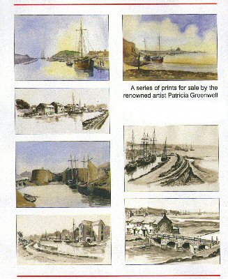 follows:- follows:-
1 Note cards and envelopes:
a) The Lower Wharf, Bude - colour
b) Sir Thomas Acland's Wharf - pen/wash
Retail price 80p each or 60p each for three or more cards
2 A4 mounted prints: Retail price £8.00 each
a) The Lower Wharf, Bude
b) Waiting for the Tide
c) Offloading outside the sea lock
d) Sir Thomas Acland's wharf
e) Bridge over the River Strat
f) Ships in the canal at Bude
g) Acland's wharf
3 A3 mounted print: Retail price £10.75 each
The Lower wharf, Bude
Notecards and A4 mounted prints can be sent by post. Please add 50p p&p
for each order of 5 notecards; please add £1 p&p for each order
of up to 3 A4 mounted prints. Unfortunately the A3 mounted print is too
large to reasonably send by post.
Bude
Canal map 1904: Plan 2.
The redrawn plan 2 which shows the canal from the 1 mile post to Pinch
Hill, Marhamchurch is now available from the Society as follows:
A4 mounted with notes £1.50.
A3 mounted with notes £10.75
A4 Plans 1 & 2 with notes in binder, £3.00
These are available by post A4 size only. Please add £1
p&p to each item. To order any of the above items by post, please
send order and full remittance to: The Treasurer, 4a The Crescent, Bude
EX23 8LE. Make cheques payable to Bude Canal & Harbour Society. Please
allow up to 28 days for delivery. Members living in the EX22 and EX23
areas can have these purchases delivered by BCHS.
back
to contents
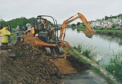
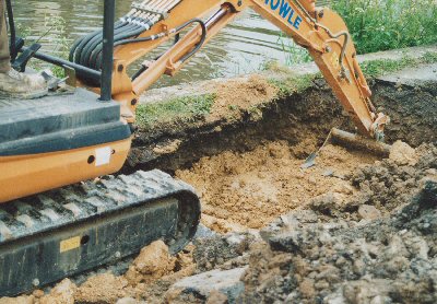
Leaking
embankment
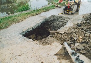
Water is leaking from the canal through the embankment into the River
Strat on the lower reaches of the canal just before the sea lock.
NCDC, the owners, are aware but initial efforts or excavation and infilling
with clay have proved fruitless. Between the overflow at the rear of the
Castle and the iron bridge there are 5 leaks, one of which is a substantial
flow of water. NCDC have engaged an engineer to deal with this matter.
Chris Jewell
|